You've probably driven through a neighborhood like this. The roads curve for no obvious reason. A street ends abruptly against a fence line when it should logically continue. A cul-de-sac loops back on itself in a way that adds two minutes to a trip that should take thirty seconds. You assume it's just bad planning — some 1960s developer who didn't think things through.
But in certain corners of America, that confusion was the point.
Scattered across the country are road layouts that were deliberately engineered to disorient, misdirect, and discourage curious eyes from getting too close to things the government didn't want them to see. It's a chapter of American infrastructure history that rarely makes it into the history books, but it's hiding right there on the map — if you know how to look.
Roads as Camouflage
The idea of using civilian infrastructure as a security tool isn't new. During World War II, the Army Corps of Engineers and private contractors worked together on projects that deliberately obscured military facilities from aerial observation — including, famously, the enormous canvas camouflage nets stretched over the Boeing aircraft plants in Seattle that made them look like suburban neighborhoods from the air.
 Photo: Boeing aircraft plants, via s-media-cache-ak0.pinimg.com
But the use of road design as ground-level camouflage is a subtler and less-documented story.
The logic is straightforward: if you don't want people wandering onto your property, you make the roads around it as confusing and discouraging as possible. Dead ends keep casual traffic from flowing through. Looping layouts create a sense that you're going in circles, encouraging people to give up and turn around. Strategically placed barriers and berms suggest that the road simply doesn't continue — when in fact it does, just not for you.
Cold War Geography
The Cold War era produced some of the most deliberate examples of this practice. As the federal government expanded its network of underground bunkers, continuity-of-government facilities, and classified research installations throughout the 1950s and '60s, road design became one layer in a broader camouflage strategy.
The famous Mount Weather Emergency Operations Center in Virginia — a classified underground facility that housed a shadow government continuity program for decades — sits in an area where the surrounding road network was carefully managed to limit access and visibility. The facility operated in plain sight as a government weather station for years, and the roads in the vicinity were laid out in ways that made casual exploration feel naturally unrewarding.
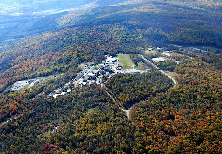 Photo: Mount Weather Emergency Operations Center, via virginiaplaces.org
Similar patterns appear around documented Cold War-era installations in Maryland, Colorado, and the Pacific Northwest. Researchers who have mapped these areas note a consistent pattern: the closer you get to a sensitive facility, the more the surrounding road network seems to fold in on itself, creating what urban planners would call a low-permeability layout — a design that dramatically reduces through-traffic and discourages navigation by anyone without a specific destination in mind.
Hiding in the Suburbs
What makes this particularly fascinating is what happened when some of these facilities were eventually decommissioned, declassified, or converted to civilian use. The buildings changed hands. The fences came down. But the roads stayed exactly where they were.
This means that right now, in ordinary American suburbs, there are neighborhoods with road layouts that were originally designed by or in consultation with federal security planners — and the people living there have absolutely no idea. The weird loop that adds three minutes to your commute? It might be there because someone in the 1950s didn't want you driving past a particular building.
In some documented cases, housing developments were built around former military or government land parcels specifically using the existing road infrastructure, which had been designed for security rather than residential convenience. The result is neighborhoods that feel subtly off — that have a layout logic that doesn't quite match how people actually want to move through a neighborhood — because they were never designed for people to move through them freely in the first place.
The Geometry of Secrecy
Urban planners have a term for road networks that are deliberately hard to navigate: they call them "low-connectivity" layouts. Modern planning philosophy generally argues against them, because connected street grids reduce commute times, improve emergency response, and encourage walkability. But for decades, low-connectivity design was actively promoted in certain contexts — and not always for the reasons the official documentation suggested.
Some planning historians have noted that the postwar American enthusiasm for cul-de-sacs and looping suburban road networks — typically attributed to a desire for quiet, private residential environments — may have been reinforced by a parallel culture within government agencies that saw low-connectivity design as a useful security tool. The aesthetics of suburban privacy and the logic of governmental secrecy happened to point in the same direction, and the two influences became difficult to separate.
Still There, Still Confusing
The next time your GPS sends you down a road that dead-ends into a fence for no obvious reason, or routes you through a cul-de-sac that feels geometrically unnecessary, it's worth a moment's curiosity. Some of those layouts are just the result of developers working around natural features or property lines. But some of them are older than the neighborhoods around them, built into the landscape for reasons that had nothing to do with housing and everything to do with keeping certain things hidden.
America's road network is usually read as a story about connection — about the national ambition to link every corner of the country to every other. But embedded in that network, if you look closely enough, is a counter-story about deliberate disconnection. About the places the roads were designed to keep you away from.
Some of those places still exist. The roads around them just make sure you don't notice.